Mynd:Lava wildfire at hawaii.jpg
Fara í flakk
Fara í leit

Stærð þessarar forskoðunar: 800 × 513 mynddílar Aðrar upplausnir: 320 × 205 mynddílar | 640 × 411 mynddílar | 1.024 × 657 mynddílar | 1.280 × 822 mynddílar | 2.200 × 1.412 mynddílar.
Upphafleg skrá (2.200 × 1.412 mynddílar, skráarstærð: 2,83 MB, MIME-gerð: image/jpeg)
|
| Lýsing |
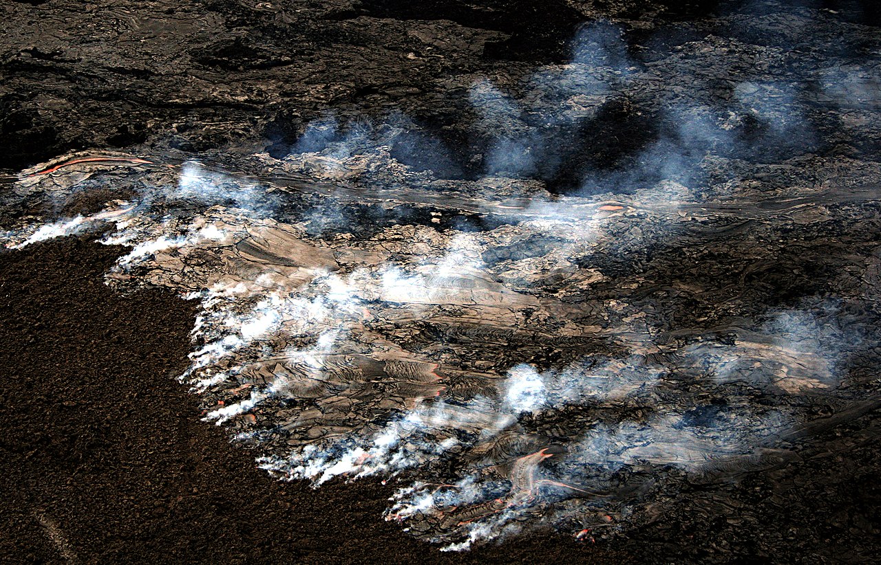
English: Pāhoehoe Lava flow on the coastal plain of Kīlauea, The Big Island of Hawai generated wildfire. The new lava is moving across the old surface, which is covered with a layer of moss about an inch thick. This moss is burning generating the smoke visible in the image. This kind of fire cannot be easily prevented or suppressed. The update that was written by USGS for the same day the image was taken - 09/04/07 says :"Lava flows advancing through vegetation are hazardous and can produce fire and methane explosions that propel chunks of lava and rock several feet into the air." The picture was taken from a helicopter.
Français : Une coulée de lave basaltique Pāhoehoe se répand sur la plaine côtière du Kīlauea, sur l'ile d'Hawaï, créant des feux. Cette nouvelle lave se répand sur une ancienne coulée couverte de mousse, qui s'enflamme, émettant la fumée visible sur la photo. Ce phénomène est dangereux car des explosions peuvent survenir, projetant des blocs de lave en fusion dans les airs. |
| Dagsetning | 09/04/07 |
| Uppruni | eigin skrá |
| Höfundarréttarhafi | Brocken Inaglory |
| Camera location | | View this and other nearby images on: OpenStreetMap |
|---|
I, the copyright holder of this work, hereby publish it under the following licenses:
Þessi skrá er með Creative Commons Tilvísun-DeilaEins 3.0 Óstaðfært notkunarleyfi.
- Þér er frjálst:
- að deila – að afrita, deila og yfirfæra verkið
- að blanda – að breyta verkinu
- Undir eftirfarandi skilmálum:
- tilvísun höfundarréttar – Þú verður að tilgreina viðurkenningu á höfundarréttindum, gefa upp tengil á notkunarleyfið og gefa til kynna ef breytingar hafa verið gerðar. Þú getur gert þetta á einhvern ásættanlegan máta, en ekki á nokkurn þann hátt sem bendi til þess að leyfisveitandinn styðji þig eða notkun þína á verkinu.
- Deila eins – Ef þú breytir, yfirfærir eða byggir á þessu efni, þá mátt þú eingöngu dreifa því verki með sama eða svipuðu notkunarleyfi og upprunalega verkið er með.

|
Gefið er leyfi til að afrita, dreifa og/eða breyta þessu skjali samkvæmt Frjálsa GNU Free Documentation License, útgáfu 1.2 eða nýrri, sem gefið er út af Frjálsu hugbúnaðarstofnuninni með engum breytingum þar á. Afrit af leyfinu er innifalið í kaflanum GNU Free Documentation License. |
Þú mátt velja notkunarleyfi að eigin vali.
Breytingaskrá skjals
Smelltu á dagsetningu eða tímasetningu til að sjá hvernig hún leit þá út.
| Dagsetning/Tími | Smámynd | Víddir | Notandi | Athugasemd | |
|---|---|---|---|---|---|
| núverandi | 18. maí 2008 kl. 14:36 | | 2.200 × 1.412 (2,83 MB) | wikimediacommons>Mbz1 | {{Information |Description=[http://en.wikipedia.org/wiki/Lava#P.C4.81hoehoe Pāhoehoe Lava] flow on the coastal plain of [http://en.wikipedia.org/wiki/Kilauea Kīlauea], [http://en.wikipedia.org/wiki/Hawaii_(island) The Big Island of Hawai] generated [htt |
Skráartenglar
Eftirfarandi síða notar þessa skrá: