Mynd:Map of Iceland.svg
Fara í flakk
Fara í leit

Stærð þessarar PNG forskoðunar á SVG skránni: 739 × 600 mynddílar. Aðrar upplausnir: 296 × 240 mynddílar | 591 × 480 mynddílar | 946 × 768 mynddílar | 1.261 × 1.024 mynddílar | 2.523 × 2.048 mynddílar | 1.834 × 1.489 mynddílar.
Upphafleg skrá (SVG-skrá, að nafni til 1.834 × 1.489 mynddílar, skráarstærð: 717 KB)
Lýsing
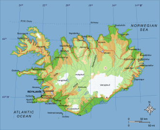
| Lýsing | A map of Iceland, showing major towns, rivers, lakes and glaciers. Translated from a map on the Greek Wikipedia (located here). |
| Dagsetning | |
| Uppruni | eigin skrá, based on File:Map of Iceland el.svg created by el:user:Αντιγόνη |
| Höfundarréttarhafi | Max Naylor |
Leyfisupplýsingar:
| This work has been released into the public domain by its author, Max Naylor. This applies worldwide. In some countries this may not be legally possible; if so: Max Naylor grants anyone the right to use this work for any purpose, without any conditions, unless such conditions are required by law. |
| Annotations | This image is annotated: View the annotations at Commons |
Breytingaskrá skjals
Smelltu á dagsetningu eða tímasetningu til að sjá hvernig hún leit þá út.
| Dagsetning/Tími | Smámynd | Víddir | Notandi | Athugasemd | |
|---|---|---|---|---|---|
| núverandi | 23. júní 2007 kl. 19:15 | | 1.834 × 1.489 (717 KB) | wikimediacommons>Max Naylor~commonswiki | == Summary == {{Information |Description=A map of Iceland, showing major towns, rivers, lakes and glaciers. Translated from a map on the Greek Wikipedia ([http://el.wikipedia.org/wiki/Εικόνα:Map_of_Iceland.svg located here]). |Source=self-made |Date |
Skráartenglar
Eftirfarandi 3 síður nota þessa skrá: